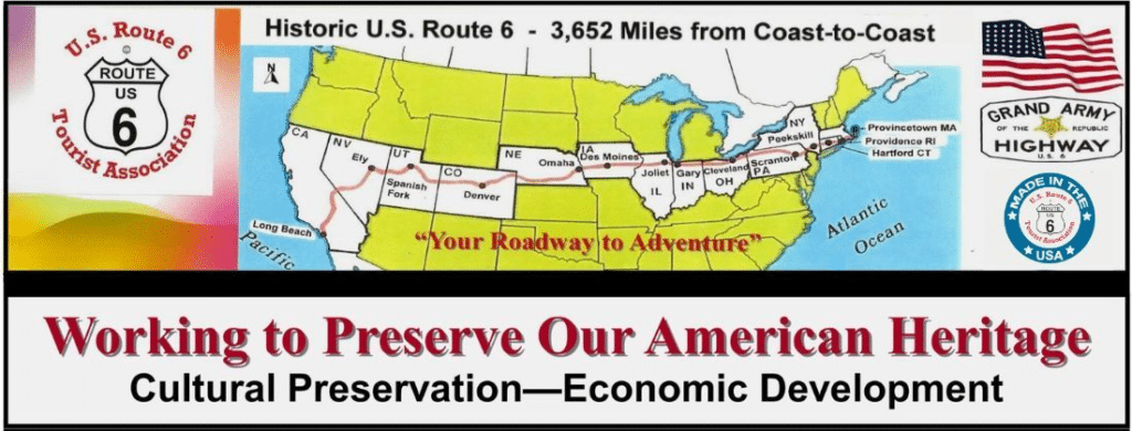
Epic Utah Road Trip: The Ultimate Itinerary Along US Route 6
There’s something magnetic about driving US Route 6 across Utah. Maybe it’s the feeling of endless horizons stretching beneath giant desert skies. Maybe it’s the contrast between lonely ghost towns, rugged canyons, and lively railroad communities. Or maybe it’s the realization that this historic highway still delivers the kind of authentic American road trip experience that’s getting harder to find elsewhere.
This itinerary follows US Route 6 from the Nevada border all the way to the Colorado border, blending iconic stops with hidden gems, practical travel tips, scenic detours, and memorable places to eat along the way.
If you’re planning a Utah road trip that combines history, adventure, and unforgettable landscapes, this route deserves a place on your list.
Quick Trip Overview
Route Summary
- Starting Point: Nevada border near Baker
- Ending Point: Colorado border east of Thompson Springs
- Recommended Duration: 4 days
- Best Time to Visit: April through early June, or September through October
- Approximate Distance: 400+ miles including detours
- Ideal Vehicle: Any reliable vehicle, though high clearance helps for some side roads
Highlights
- Topaz War Relocation Center
- Delta’s historic downtown
- Price Canyon
- Nine Mile Canyon
- Historic Helper
- Goblin Valley State Park
- Moab
- Arches National Park
Suggested Map Route
A custom Google Maps route works best for this trip. Include these waypoints:
- Wendover
- Delta
- Price
- Helper
- Green River
- Goblin Valley State Park
- Moab
- Thompson Springs
Offline maps are strongly recommended because cell service disappears in several stretches between towns.
BONUS:
To save a Google Map for offline use, open the app while connected to Wi-Fi, tap your profile picture, select Offline maps, and then “Select your own map”. Pan and zoom to your desired area, then tap “Download.” This allows turn-by-turn driving navigation and searching without data.
How to Download Offline Maps
- Open Google Maps: Ensure you are connected to the internet/Wi-Fi.
- Search for a Location: Type the city, area, or region you plan to visit (e.g., “Paris”).
- Download the Area:
- Tap the name or address of the place at the bottom of the screen.
- Tap the three-dot menu icon (more) and select Download offline map.
- Alternatively: Go to your Profile Picture > Offline maps > Select your own map.
- Adjust and Confirm: Pinch to zoom or move the box to cover the desired area, then tap Download.
Important Tips for Offline Usage
- Storage & Limits: Offline maps can take up significant storage; large areas might require multiple downloads.
- Limitations: Offline maps only provide driving directions, not walking, cycling, or transit routes. Traffic data and lane guidance will not be available.
- Expiration: Downloaded maps expire after 15 days or up to one year if they are not used.
- SD Card: Android users can save maps to an SD card by tapping Profile Picture > Offline maps > Settings (gear icon) > Storage preferences > SD card.
How to Use Offline Maps
Once the download is complete, simply open the Google Maps app as you normally would when you have no signal. It will automatically use the downloaded map data.
Day 1: Nevada Border to Delta
Driving Distance
Approximately 170 miles
Best For
History lovers, desert landscapes, and quiet small towns
Crossing into Utah from Nevada feels like entering another world. The landscape opens into broad desert valleys ringed by distant mountain ranges, and traffic thins out almost immediately. It is the kind of drive where you naturally slow down and start noticing details you would normally miss.
Stop 1: Great Basin Desert Views
Before reaching Delta, take time to appreciate the stark beauty of western Utah. Early morning light turns the desert gold, while sunset creates deep purple shadows across the mountains.
Best Time to Visit
- Sunrise or sunset for photography
- Spring for wildflowers
Costs
- Free
Travel Tip
Carry extra water. Services are sparse for long stretches.
Stop 2: Topaz War Relocation Center
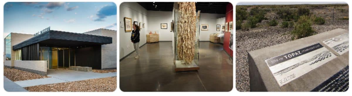
The Topaz War Relocation Center stands as one of the most important historical sites along US Route 6.
During World War II, thousands of Japanese Americans were forcibly relocated here and confined in harsh desert conditions. Walking the interpretive trails and visiting the museum is a sobering experience that stays with you long after you leave.
The landscape itself tells part of the story. Winds whip across the desert, and the isolation becomes immediately apparent.
Plan Your Visit
- Allow 1 to 2 hours
- Museum admission is modestly priced
- Outdoor interpretive areas are free
- Donations help preserve the site
Best Time to Visit
- Spring and fall for cooler weather
Why It Matters
This stop adds emotional depth to the road trip and offers a powerful reminder of an important chapter in American history.
Stop 3: Delta Historic Downtown
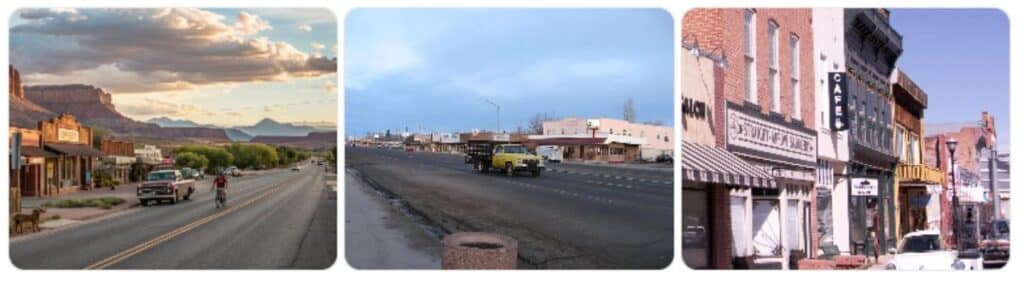
After the emotional weight of Topaz, Delta provides a welcoming small-town atmosphere.
I remember arriving near dusk and watching the warm light hit the old storefronts downtown. There’s a quiet pride here that reflects the agricultural roots of the region.
Things to Do
- Explore historic downtown
- Visit local shops
- Photograph vintage signs
- Grab dinner before the next leg of the trip
Food Recommendation
Try a classic Utah diner experience with:
- Chicken fried steak
- Homemade pie
- Fry sauce with fries
Local cafés often close early, so arrive before evening if possible.
Overnight Recommendation
Delta makes an excellent overnight stop because accommodations are affordable and centrally located.
Day 2: Delta to Helper
Driving Distance
Approximately 160 miles plus canyon detours
Best For
Scenic drives, rock art, and mountain canyons
Day 2 is where the scenery starts changing dramatically. Desert flats slowly give way to rocky hills, mountain passes, and narrow canyon corridors.
This stretch feels cinematic.
Stop 1: Price Canyon
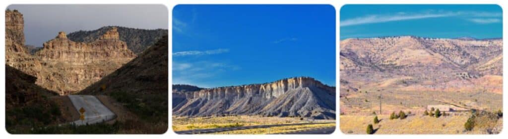
Driving through Price Canyon is one of the great scenic sections of US Route 6.
Towering cliffs rise beside the highway while trains snake through the canyon below. In autumn, the cottonwoods and aspens create flashes of yellow against the red rock walls.
Best Time to Visit
- Fall for foliage
- Early morning for softer light
Costs
- Free scenic drive
Travel Tip
Watch weather forecasts carefully in winter. Snow and ice can make the canyon hazardous.
Stop 2: Nine Mile Canyon
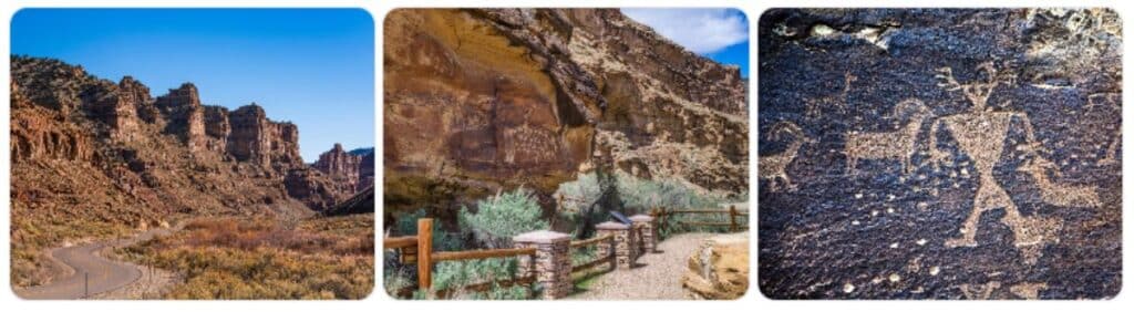
Despite its name, Nine Mile Canyon stretches much farther and contains one of the largest collections of rock art in North America.
This detour is absolutely worth the extra time.
Petroglyphs and pictographs line the canyon walls, some dating back over a thousand years. Standing beside these ancient markings creates a rare sense of connection to the people who traveled this landscape centuries before highways existed.
Must-See Panels
- Great Hunt Panel
- Big Buffalo Panel
Best Time to Visit
- Morning or late afternoon
- Avoid summer midday heat
Costs
- Free
Road Conditions
Mostly graded roads, but conditions can change after storms.
Stop 3: Historic Helper
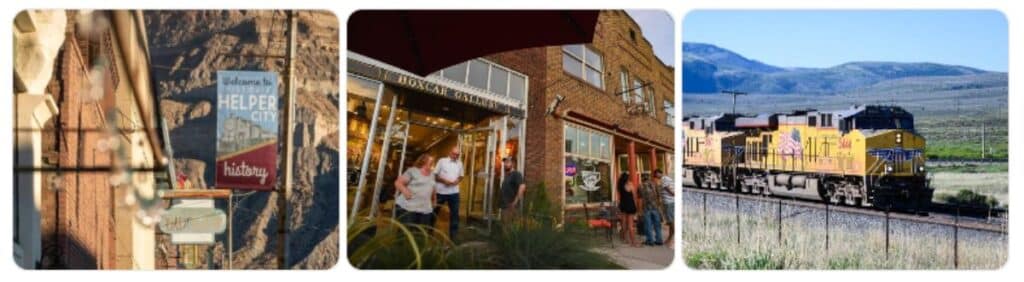
Helper might be my favorite small town on the route.
Originally built as a railroad helper town for locomotives climbing steep grades, Helper has reinvented itself as an arts and history destination without losing its gritty authenticity.
Brick buildings line the streets, murals decorate downtown walls, and old railroad heritage remains everywhere you look.
Things to Explore
- Western Mining and Railroad Museum
- Local art galleries
- Historic downtown architecture
Food Recommendation
Order:
- Smoked brisket
- Burgers
- Green chile dishes
Several cafés in town serve surprisingly excellent coffee for such a small community.
Overnight Recommendation
Spend the night in Helper to fully enjoy the atmosphere after dark.
Day 3: Helper to Green River via Goblin Valley
Driving Distance
Approximately 140 miles including detour
Best For
Desert adventure and surreal landscapes
This day delivers some of Utah’s strangest and most unforgettable scenery.
Stop 1: Goblin Valley State Park
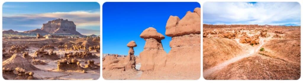
Goblin Valley State Park feels like another planet.
Thousands of mushroom-shaped hoodoos spread across the valley floor, creating a landscape that looks almost unreal. Unlike many parks, visitors can freely wander among the formations.
I arrived here in late afternoon once, and the changing light transformed the rocks from pale tan to glowing orange. It was impossible to stop taking photos.
Entry Fees
- State park entrance fee required
- Check seasonal rates before arrival
Best Time to Visit
- Sunrise or sunset
- Spring and fall for comfortable temperatures
Travel Tip
Bring plenty of water and sun protection. Shade is limited.
Optional Adventure: Little Wild Horse Canyon
If time allows, nearby Little Wild Horse Canyon offers one of Utah’s best slot canyon hikes.
Difficulty
Moderate
Permit
Usually no permit required for day hiking
Warning
Avoid entering slot canyons if storms are forecast due to flash flood risk.
Stop 2: Green River
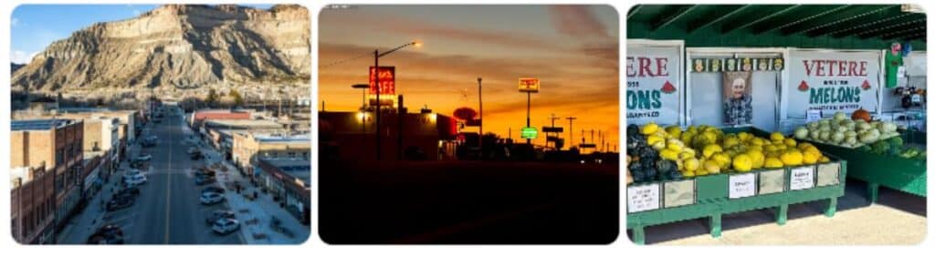
Green River serves as a classic Western road trip stop.
The town has long been a gateway for travelers crossing Utah’s canyon country. Vintage motels, old neon signs, and melon stands give it a nostalgic highway feel.
Food Recommendation
Green River is famous for melons during harvest season.
Also look for:
- Green chile burritos
- Classic diner breakfasts
- Utah-style burgers
Best Time to Visit
Late summer for melon season.
Day 4: Green River to the Colorado Border
Driving Distance
Approximately 120 miles plus park exploration
Best For
National parks and iconic red rock scenery
The final day features some of Utah’s most recognizable landscapes.
Stop 1: Moab
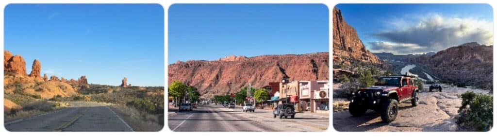
Moab has evolved into one of the West’s premier outdoor destinations, but it still retains enough rugged character to feel adventurous.
The energy here is contagious. Jeeps rumble through downtown, hikers gather in coffee shops before sunrise, and cyclists return dusty from desert trails.
Things to Do
- Explore downtown
- Visit local outfitters
- Try regional Southwestern cuisine
- Photograph the red cliffs at sunset
Food Recommendation
Look for:
- Navajo tacos
- Wood-fired pizza
- Green chile enchiladas
Best Time to Visit
Spring and fall offer the most comfortable weather.
Costs
Moab itself is free to explore, though nearby parks charge entrance fees.
Stop 2: Arches National Park
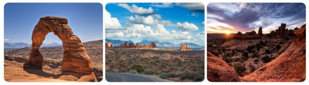
No Utah road trip along US Route 6 feels complete without visiting Arches National Park.
The park contains more than 2,000 natural stone arches along with towering fins, balanced rocks, and dramatic desert vistas.
Must-See Stops
- Delicate Arch
- Balanced Rock
- Landscape Arch
- Park Avenue viewpoint
Timed Entry Reservations
Depending on season, timed entry reservations may be required.
Entry Fees
National park entrance fee applies.
Best Time to Visit
- Sunrise for photography
- Spring and fall for hiking
Travel Tip
Start early. Parking lots fill quickly during busy seasons.
Final Stretch: Toward the Colorado Border
East of Moab, the highway becomes quieter again as it approaches the Colorado line.
This final stretch feels reflective. After days of canyons, deserts, small towns, and historic landmarks, the road slowly transitions toward the Rockies beyond the border.
It is the kind of journey that reminds you why classic American road trips still matter.
Hidden Gems Along the Route
Thompson Springs
A nearly forgotten railroad town with old buildings and desert charm.
Desert Wildflowers
Spring travelers may see surprisingly colorful blooms across the desert plains.
Railroad Watching
Freight trains frequently parallel the highway through canyon country.
Packing Tips for a Utah US Route 6 Road Trip
Essentials
- Extra drinking water
- Paper maps or offline navigation
- Sunscreen
- Layers for temperature swings
- First aid kit
- Spare tire and emergency supplies
Photography Gear
- Wide-angle lens
- Tripod for sunrise and sunset shots
- Extra batteries
Safety Notes
Utah’s beauty comes with real challenges.
Important Reminders
- Cell service is unreliable in remote areas
- Flash floods can occur suddenly
- Fuel stations may be far apart
- Summer temperatures can exceed 100°F
Always check weather and road conditions before heading into remote areas.
Final Thoughts
Driving US Route 6 across Utah feels like traveling through multiple worlds in a single trip. One day you are reflecting on history at Topaz. The next you are wandering through ancient rock art canyons or standing beneath towering sandstone arches.
What makes this route special is not just the scenery. It is the feeling of discovery. US Route 6 still rewards curiosity in ways many highways no longer do.
Take your time here. Stop in the small towns. Talk with locals. Watch the sunset from the side of the road. Those moments often become the memories that stay with you longest.
If you have driven this stretch of US Route 6, I would love to hear about your favorite stops, hidden gems, and road trip discoveries. Share your experiences and help inspire the next traveler to explore this unforgettable Utah journey.
Subscribe today and let Route 6 come to you, one story at a time.